Navigation

    Aquanty Logo

    HydroGeoSphere Community

    • Register
    • Login
    • Search
    1. Home
    2. bmcneill
    • Profile
    • Following 0
    • Followers 7
    • Topics 29
    • Posts 29
    • Best 14
    • Groups 1

    Brayden McNeill

    @bmcneill

    Technical Sales and Marketing Lead at Aquanty

    167
    Reputation
    64
    Profile views
    29
    Posts
    7
    Followers
    0
    Following
    Joined Last Online
    Email bmcneill@aquanty.com Location Kitchener, ON Age 33

    bmcneill Unfollow Follow
    administrators

    Best posts made by bmcneill

    • Research Highlight: Dual-permeability modeling of preferential flow and snowmelt partitioning in frozen soils

      Dual-permeability modeling of preferential flow and snowmelt partitioning in frozen soils

      AUTHORS: Aaron A. Mohammed, Edwin E. Cey, Masaki Hayashi, Michael V. Callaghan, Young-Jin Park, Killian L. Miller, Steven K. Frey

      The study highlighted this month introduces a dual-permeability model which integrates the dynamics of soil free-thaw cycles and preferential flow on infiltration and runoff generation in structured soils. This formulation was incorporated successfully into HydroGeoSphere.

      Link to the article

      Abstract:

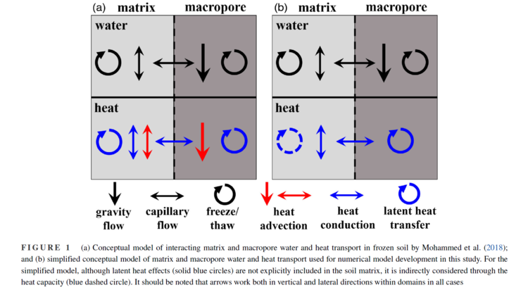
      The infiltrability of frozen soils modulates the partitioning of snowmelt between infiltration and runoff in cold regions. Preferential flow in macropores may enhance infiltration, but flow dynamics in frozen soil are complicated by soil heat transfer processes. We developed a dual-permeability model that considers the interacting effects of freeze–thaw and preferential flow on infiltration and runoff generation in structured soils. This formulation was incorporated into the fully integrated groundwater–surface water model HydroGeoSphere, to represent water–ice phase change in macropores such that porewater freezing is governed by macropore–matrix heat exchange.

      image 1.png
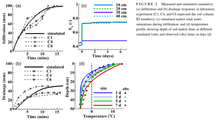
      Model performance was evaluated against laboratory experiments and synthetic test cases designed to examine the effects of preferential flow on snowmelt partitioning between infiltration, runoff, and drainage. Simulations were able to reproduce experimental observations of rapid infiltration and drainage behavior due to macropores very well, and approximated soil thaw to an acceptable degree. Simulation of measured data highlighted the importance of macropore hydraulic conductivity, as well as macropore–matrix heat and water transfer, on controlling preferential flow dynamics. Test cases replicated a range of snowmelt partitioning behavior commonly observed in frozen soils, including subsurface conditions that produce rapid infiltration and deeper drainage, the contrast between limited vs. unlimited infiltration responses to snowmelt, and the temporal evolution of runoff generation. This study demonstrates the important influence that water freezing along preferential flowpaths can have on infiltrability and runoff characteristics in frozen soils and provides a physically based description of this mechanism that links infiltration behavior to hydraulic and thermal properties of structured soils.

      image 2.png
      Link to the article

      posted in HGS Research Highlights
      bmcneill
      bmcneill
    • HGS RESEARCH HIGHLIGHT – Simulating preferential flow and snowmelt partitioning in seasonally frozen hillslopes

      AUTHORS: Aaron A. Mohammed, Edwin E. Cey, Masaki Hayashi, Michael V. Callaghan

      This research highlights the ability to model pore-water freeze/thaw and how it impacts the partitioning of snowmelt into infiltration, runoff and groundwater recharge in seasonally frozen hillslopes.

      This research follows on an earlier highlight by author Aaron Mohammed about the development of a dual-permeability model which integrates the effects of soil freeze-thaw and preferential flow on infiltration and runoff generation in structured soils. This formulation was incorporated successfully into HydroGeoSphere. Read the original research highlight here.

      CLICK HERE TO READ THE ARTICLE.

      Abstract:

      The infiltrability of frozen soils strongly influences snowmelt partitioning and redistribution in cold regions. Preferential flow in frozen soil can enhance infiltration, but dynamics are complicated by coupled water and heat transfer processes as well as landscape conditions prior to and during snowmelt.

      Capture1.PNG

      Model simulations in HydroGeoSphere, based on hydrological functioning and landscape properties of the Canadian Prairies, were used to evaluate a dual-domain (matrix and macropore) formulation of variably-saturated flow in frozen soils, with distinct water and heat transport regimes in each domain.

      Capture2.PNG

      Two-dimensional hillslope simulations were able to capture the landscape hydrologic response to snowmelt fluxes observed in the Prairies and similar landscapes, specifically: (1) enhanced infiltration into frozen soil due to preferential flow, (2) refreezing of infiltrated water and its effect on the evolution of runoff generation in frozen soils, and (3) groundwater recharge prior to ground thaw. Results showed that multiple meltwater input events progressively decreased frozen soil infiltrability and increased runoff generation. Simulations demonstrated that refreezing of infiltrated water along preferential flowpaths is an important process governing the timing and magnitude of both runoff generation and groundwater recharge in frozen soils, but that this behaviour can be highly counterintuitive and depends on soil structure. The modeling framework provides a physically-based approach for describing these interacting preferential flow and soil freezing processes at the hillslope scale needed to simulate the hydrologic functioning of seasonally frozen landscapes.

      Capture4.PNG

      CLICK HERE TO READ THE ARTICLE.

      posted in HGS Research Highlights
      bmcneill
      bmcneill
    • HGS RESEARCH HIGHLIGHT – Development of an integrated numerical flow model in the Prairie Environment

      AUTHORS: Arefin Haque, Amgad Salama, Kei Lo, Peng Wu

      A recent publication by researchers at the University of Regina uses HydroGeoSphere to investigate the impact of climate variability and different groundwater withdrawal scenarios on groundwater levels in the Leech Lake aquifer. This paper provides an excellent introduction to the use of HGS in semi-arid prairie regions, making use of the built-in evapotransporation and snowmelt processes to estimate overall recharge rates under various climate scenarios (including extreme drought).

      “The interaction between surface water and groundwater is complicated due to the existence of many factors, such as uncertainty of land cover and aquifer properties, which can cause substantial errors in model output (Eslamian and Nekoueineghad, 2009; Sophocleous, 2010; Straatsma et al., 2013). A fully-integrated, physically-based numerical model is well capable of handling these factors (Alaghmand et al., 2014). HydroGeoSphere (HGS), fully integrated model has been selected for this research because of its capability to address some of these complexities while considering a large scale study (Therrien, 2011). HydroGeoSphere can simulate the dynamic interactions between all sub-domains at each time step.”

      “In HGS, rainfall precipitation is branched into components such as evapotranspiration, runoff and infiltration. HGS allows for the computation of water infiltration or exfiltration between rivers, lakes and aquifers. These interactions play a significant role in the prediction of future scenarios with respect to climate change, since recharge (precipitation, snowmelt) is very susceptible to climatic fluctuations.”

      This study was co-authored by researchers at the University of Regina (Faculty of Engineering and Applied Science) and the Saskatchewan Water Security Agency. For more information, please contact the corresponding author Peng Wu (Assistant Professor and Program Chair, Environmental Systems Engineering; Peng.Wu@uregina.ca).

      CLICK HERE TO READ THE ARTICLE.

      ABSTRACT:
      Study focus: Groundwater and surface water interactions have been conducted numerically for bringing out a sustainable management of the Leech Lake aquifer in the southern portion of City of Yorkton area within the province of Saskatchewan, Canada. The aquifer is composed of highly conductive sediments over bedrock strata with low hydraulic conductivity. A fully coupled, physically based surface-groundwater flow model using HydroGeoSphere (HGS) is developed for the purpose of simulation. In this numerical model, different withdrawal scenarios and the effects of climate variabilities (precipitation and snowmelt) are being conducted to investigate the impact of water usage on groundwater level.

      capture 1.jpg
      Fig. 4. (a) 2-D mesh for overland flow (surface domain); (b) a slice of 3-D mesh for subsurface domain.

      New hydrological insights for the region: Groundwater from several aquifers serves as the main water supply for the city of Yorkton. Aquifer protection and sustainable use of the limited resource is of utmost importance to the municipality and in support of economic development in the region. Insight and understanding of the risks and impact to the municipal groundwater supply is required. To address the sustainability of the aquifers in the area, a numerical model was developed to provide greater comprehension of the surface and groundwater fluxes. Model calibration and validation was completed with existing long term monitoring information from piezometers in the area. In the semi-arid environment of the Prairie Provinces, water withdrawal and precipitation plays a significant role in affecting groundwater level. Different withdrawal scenarios are conducted to investigate the impact of the water usage on the Leech Lake aquifer that will provide a tool to support the development of a sustainable management plan. Precipitation as well as snowmelt have been incorporated into the model to identify the driving recharge factor for groundwater variation. Temporal and spatial variabilities, as well as estimation of magnitude for exchange flow rates at the interfaces are presented. The fully integrated model developed in this study provides the foundation for future groundwater management applications in climate driven changes within the Prairie environment.

      capture 2.jpg
      Fig. 5. Overland flow (surface) domain at the finishing time of the simulation period of 14 years; (a) elevation contours, Z and (b) water depth contours.

      capture 3.jpg
      Fig. 16. Relative comparison and major recharge factor identification between precipitation and snowmelt for the entire simulation period (2002–2015).

      posted in HGS Research Highlights
      bmcneill
      bmcneill
    • HGS RESEARCH HIGHLIGHT – Storm Surges and Coastal Salinization/Saltwater Intrusion

      This week’s research highlight introduces two papers by Dr. Holly Michael’s research group at the University of Delaware – papers which bring attention to the impact of storm surges on coastal salinization/saltwater intrusion under a changing climate, and on the subsequent impact of saltwater flooding on crop-yields in adjacent agricultural lands.

      Dr. Holly Michael (hmichael@udel.edu) is corresponding author for both papers.

      Paper #1: Effects of Marsh Migration on Flooding, Saltwater Intrusion, and Crop Yield in Coastal Agricultural Land Subject to Storm Surge Inundation

      AUTHORS: Julia A. Guimond and Holly A. Michael

      CLICK HERE TO READ PAPER #1

      Abstract: Low-lying coastlines are vulnerable to sea-level rise and storm surge salinization, threatening the sustainability of coastal farmland. Most crops are intolerant of salinity, and minimization of saltwater intrusion is critical to crop preservation. Coastal wetlands provide numerous ecosystem services, including attenuation of storm surges. However, most research studying coastal protection by marshes neglects consideration of subsurface salinization. Here, we use two-dimensional, variabledensity, coupled surface-subsurface hydrological models to explore how coastal wetlands affect surface and subsurface salinization due to storm surges. We evaluate how marsh width, surge height, and upland slope impact the magnitude of saltwater intrusion and the effect of marsh migration into farmland on crop yield. Results suggest that along topographically low coastlines subject to storm surges, marsh migration into agricultural fields prolongs the use of fields landward of the marsh while also protecting groundwater quality. Under a storm surge height of 3.0 m above mean sea level or higher and terrestrial slope of 0.1%, marsh migration of 200 and 400 m protects agricultural yield landward of the marshfarmland interface compared to scenarios without migration, despite the loss of arable land. Economic calculations show that the maintained yields with 200 m of marsh migration may benefit farmers financially. However, yields are not maintained with migration widths over 400 m or surge height under 3.0 m above mean sea level. Results highlight the environmental and economic benefits of marsh migration and the need for more robust compensation programs for landowners incorporating coastal wetland development as a management strategy.

      Capture1.PNG
      Capture2.PNG

      CLICK HERE TO READ PAPER #1

      Paper #2: Storm Surges Cause Simultaneous Salinization and Freshening of Coastal Aquifers, Exacerbated by Climate Change

      AUTHORS: Anner Paldor and Holly A. Michael

      CLICK HERE TO READ THE PAPER #2

      Abstract: Ocean surge events are known to threaten coastal aquifers through vertical infiltration, with the degree of salinization depending on hydrogeologic factors. Another salinization process in coastal aquifers is lateral saltwater intrusion, which may also be affected during surges as the inundation alters the aquifer hydraulic heads. While these processes have been considered individually, here we consider the interplay between them and the longer-term impact of climate change, which is projected to increase the frequency of surges in the future. Using numerical modeling, the location of the lateral freshwater-saltwater interface and the total salt storage are calculated for single and repetitive surge events with different recurrence times to predict the long-term effect of surges. Results point to two novel mechanisms: (1) Following a single overwash event, salt storage in the aquifer peaks due to vertical salinization, and a second, lower peak occurs on a longer time scale. This second peak is due to the surge-induced rebound motion (seaward and then landward) of the interface. (2) The projected increase in surge frequency due to climate change can potentially induce long-term migration of the interface seaward, independent of a change in sea level, depending on the aquifer permeability. Together with this freshening effect, the total salt load in the aquifer increases due to repetitive vertical salinization. Thus, we show for the first time the combined effect of storm surges and climate change on both vertical and horizontal movement of salt in coastal aquifers, with important implications for water management along global coastlines.

      Capture3.PNG
      Capture4.PNG

      CLICK HERE TO READ THE PAPER #2

      posted in HGS Research Highlights
      bmcneill
      bmcneill
    • HGS RESEARCH HIGHLIGHT – Integrated modelling to assess climate change impacts on groundwater and surface water in the Great Lakes Basin using diverse climate forcing

      New research by Aquanty personnel and researchers at the University of Guelph evaluates climate change risks in the Upper Parkhill Creek watershed, a clay plain system within the Great Lakes Basin with land-use being dominated by agriculture. Key model outputs including groundwater hydraulic head, surface discharge, and net fluid exchange between surface and subsurface domains were assessed under eight different climate projections informed by the RCP 8.5 emission scenario.

      Click here to read the research highlight on our blog.

      posted in HGS Research Highlights
      bmcneill
      bmcneill
    • HGS RESEARCH HIGHLIGHT – Evaluating Landscape Influences on Hydrologic Behavior with a Fully-Integrated Groundwater – Surface Water Model

      New research has been published on Aquanty’s work modeling the Oak River Watershed in south-west Manitoba, Canada. The work here seeks to quantify the impact of land use change on the hydrologic system. This paper also introduces a watershed-scale application of the numerical formulation to apply spatially variable rill (depressional) storage, and one-dimensional channel flow using HydroGeoSphere.

      Click here to read the research highlight on our blog.

      posted in HGS Research Highlights
      bmcneill
      bmcneill
    • HGS RESEARCH HIGHLIGHT – The Response of the HydroGeoSphere Model to Alternative Spatial Precipitation Simulation Methods

      Check out our most recent HGS research highlight here.

      This new research should help HGS users to select a suitable method for the spatial distribution/interpolation of precipitation data at different scales. The study evaluates three different methods of spatially distributing precipitation data – including Thiessen Polygons (TP), Co-Kriging (CK) and Simulated Annealing (SA) - at two different watershed scales using HydroGeoSphere.

      posted in HGS Research Highlights
      bmcneill
      bmcneill
    • HGS RESEARCH HIGHLIGHT – Estimating Anthropogenic Effects on a Highly-Controlled Basin with an Integrated Surface-Subsurface Model

      Our ongoing research with partners at the Korea Institute of Geoscience and Mineral Resources has led to a new publication. This paper seeks to quantify the impacts of water management practices (e.g. groundwater pumping, dam and weir operations, etc.) on the surface and groundwater system of the Geum River Basin, South Korea.

      Click here to read the research highlight on our blog.

      Research_Highlight_GRB.png

      posted in HGS Research Highlights
      bmcneill
      bmcneill
    • HGS RESEARCH HIGHLIGHT – Using depth specific electrical conductivity estimates to improve hydrological simulations in a heterogeneous tile-drained field

      A new study, which is part of the PhD project of Vinicius Boico and co-authored by Aquanty co-founder Rene Therrien, uses HydroGeoSphere to explore the impact of soil heterogeneity on simulated hydrology of a highly-instrumented, tile-drained agricultural field in Denmark. Results of the integrated hydrologic simulations indicate that homogeneous soil layers can effectively reproduce overall drainage and flow volumes at this scale. However, the inclusion of clay layers provides a much better representation of hydraulic heads throughout the field, a necessity for the accurate simulation of solute transport in agricultural catchments.

      Click here to read the research highlight on our blog.

      Capture.PNG
      3D HydroGeoSphere Model of the Study Area in Denmark

      posted in HGS Research Highlights
      bmcneill
      bmcneill
    • HGS RESEARCH HIGHLIGHT – A hybrid approach for integrated surface and subsurface hydrologic simulation of baseflow with Iterative Ensemble Smoother

      This paper introduces the development of an integrated model for the South Québec region where low-flow processes are of primary concern. In this publication, HydroGeoSphere is used with a surface water mass balance module in order to reduce computational cost, enabling the use of mathematically rigorous, ensemble-based methods to support a calibration-constrained predictive uncertainty analysis.

      This study is one of the first instances of a non-linear predictive uncertainty analysis for a regional scale and integrated surface and subsurface hydrologic model.

      Click here to read the research highlight on our blog.

      Capture2.PNG
      3D HydroGeoSphere Model of the Study Area in Southern Quebec, Canada

      posted in HGS Research Highlights
      bmcneill
      bmcneill

    Latest posts made by bmcneill

    • Webinar! Thermal Energy Transport and Saltwater Intrusion Modelling with HydroGeoSphere

      Did you miss our recent webinar? Not to worry, we recorded the presentations. Find them here on the Aquanty blog: https://www.aquanty.com/blog/thermal-energy-transport-and-saltwater-intrusion-modelling-with-hydrogeosphere

      posted in HGS Research Highlights
      bmcneill
      bmcneill
    • HydroGeoSphere Research Highlight - Physics based hydrological modeling to predict soil moisture in a cold climate mesoscale catchment

      Thank you @Keshav (one of our newest hires) for sharing his research with the rest of the team.

      In this study HydroGeoSphere model was constructed for an agriculturally dominated watershed in the Red River Valley, Manitoba, to determine the soil moisture variability in cold climate in deeper soil layers. #climatechange is expected to produce more fluctuations in precipitation across the globe and cause more frequent extremes in soil moisture, including floods and drought which have major impacts on agriculture and infrastructure. Forecasting can help mitigate the impacts of soil moisture extremes by providing warnings about upcoming extreme events and prompt mitigation measures.

      https://www.aquanty.com/blog/physics-based-hydrological-modeling-predict-soil-moisture-cold-climate-mesoscale-catchment

      posted in HGS Research Highlights
      bmcneill
      bmcneill
    • HGS RESEARCH HIGHLIGHT – Subglacial Meltwater Recharge in the Dongkemadi River Basin, Yangtze River Source Region

      This HydroGeoSphere paper investigates the influence that the Dongkemadi Glacier (on the Tibetan Plateau) and deglaciation plays on catchment scale hydrologic processes:

      https://www.aquanty.com/blog/hgs-research-highlight-subglacial-meltwater-recharge-dongkemadi-river-basin

      @qiule-He

      posted in HGS Research Highlights
      bmcneill
      bmcneill
    • HGS RESEARCH HIGHLIGHT – Analysis of drought conditions and their impacts in a headwater stream in the Central European lower mountain ranges

      A study by researchers at the University of Bayreuth (@Sven-Frei @Sven-Frei-0) investigating the impacts that climate change may have on drought conditions in forested catchment with riparian wetland. There will likely be a shift in the water balance resulting in increases drought duration, intensity, and frequency.

      This study provides a potential blueprint for those interested in simulating climate change impacts on hydrology at the catchment scale.

      Read about it on the Aquanty blog: https://www.aquanty.com/blog/hgs-research-highlight-analysis-drought-conditions-impacts-headwater-stream-mountain-ranges

      posted in HGS Research Highlights
      bmcneill
      bmcneill
    • HGS RESEARCH HIGHLIGHT – Impacts of Coastal Shrimp Ponds on Saltwater Intrusion and Submarine Groundwater Discharge

      This paper investigates the potential impact that aquaculture can have on solute transport and saltwater intrusion in coastal settings. In shrimp pond #aquaculture, saline ponds are perched on top of agricultural soils above a freshwater aquifer. In this study the authors have investigated several scenarios (varying pond water salinity, ponded water depth and farm/pond width) to see how it impacts a previously unstudied process contributing to groundwater salinization.

      https://www.aquanty.com/blog/hgs-research-highlight-impacts-coastal-shrimp-ponds-saltwater-intrusion-submarine-groundwater-discharge

      @Xuan-Yu

      posted in HGS Research Highlights
      bmcneill
      bmcneill
    • HGS RESEARCH HIGHLIGHT – Dynamic Steady State in Coastal Aquifers Is Driven by Multi‐Scale Cyclical Processes, Controlled by Aquifer Storativity.

      A new paper by our friends at the University of Delaware explores the effects that periodic/cyclical processes over different time scales exert on salinity distribution throughout coastal aquifers. In other words, how is aquifer salinity impacted by sea-level changes caused by tidal effects (sub-daily), storm-surges (decadal) and glaciation (millennial scale).

      @anner-paldor @rsfrederiks

      Read more on the Aquanty blog.

      posted in HGS Research Highlights
      bmcneill
      bmcneill
    • HGS RESEARCH HIGHLIGHT – Sources of surface water in space and time: Identification of delivery processes and geographical sources with hydraulic mixing-cell modeling

      The paper highlighted this week (co-authored by @ReneTherrien) presents a very interesting post-processing method for HydroGeoSphere models. The results of the HGS model were used as input into the hydraulic mixing-cell (HMC) approach which enables tracking and delineation of the mixing of predefined initial water sources at any location and at any time based on information from the hydraulic flow solution.

      Read more on the Aquanty blog.

      posted in HGS Research Highlights
      bmcneill
      bmcneill
    • HGS RESEARCH HIGHLIGHT – Transit-Time and Temperature Control the Spatial Patterns of Aerobic Respiration and Denitrification in the Riparian Zone

      The study here (co-authored by @Gui_Nogueira) introduces a novel method of implementing temperature-dependent reactions in a HydroGeoSphere solute transport model by pairing a Lagrangian flow path-reaction model to the results of a 2nd order Runge-Kutta particle tracking analysis. HGS does not currently support temperature dependent reaction rates, but there is always a way!

      Read more on the Aquanty blog.

      posted in HGS Research Highlights
      bmcneill
      bmcneill
    • HGS RESEARCH HIGHLIGHT – Finite-volume flux reconstruction and semi-analytical particle tracking on triangular prisms for finite-element-type models of variably-saturated flow

      This research highlight details a new method to reconstruct finite-volume flux fields from finite element models such as HGS, and an accompanying semi-analytical particle tracking method. The code used in this paper is available for download from the author's Github page.

      Read more on the Aquanty blog.

      floodplain_trajectories_2.png

      posted in HGS Research Highlights
      bmcneill
      bmcneill
    • HGS RESEARCH HIGHLIGHT – Predicting Watershed Scale Surface Water Quality Targets With a Combined Fully-Integrated Groundwater-Surface Water Model and Machine Learning Approach

      This research highlights Aquanty's interesting work at the nexus of physics based integrated hydrologic modelling and machine learning/artificial intelligence techniques. Here the authors have paired a HydroGeoSphere model of the South Nation Watershed (SNW) with a Random Forest (RF) algorithm trained to predict spatially varying concentrations of nitrate and E. Coli throughout the watershed.

      Read more on the Aquanty blog.

      Capture.PNG
      The South Nation Watershed (SNW) HydroGeoSphere Model

      posted in HGS Research Highlights
      bmcneill
      bmcneill